

While many consider flying an FPV aircraft the greatest hobby in the world, (me among them!) what other uses does an UAV (Unmanned Flying Vehicle) have? What great and wonderful things can we do with these amazing aircraft? Let’s explore what people use them for in today’s world.
Aerial Photography
One of the first and most common things that you will see UAV’s used for is photography. While this comes in various forms, many of which we will get into later, let just look at the average hobbyist photographer. While shooting photos with a camera is an excellent hobby that many enjoy, sometimes getting those amazing shots from above really sets the tone for a photo or video. Things look different when viewed from a different elevation, and can change the experience of viewing that particular place or object.
One need only look at a YouTube videos from many of the pilots out there for examples and inspiration, but the first that comes to mind are the videos from Team Blacksheep, one of which can be viewed below.
[vc_row][vc_column][vc_video link=”https://youtu.be/YLb6I4PaxdY” align=”center”][/vc_column][/vc_row]
Do you need specialized gear beyond your FPV rig? No, if you want to capture epic shots like those in the video, those were all captured with an FPV quadcopter. If you want to be able to do slow steady shots and have a camera on a gimbal that doesn’t require you to reorient your aircraft, then investment in something meant for that task would be a good idea. Something like a DJI Mavic Mini to get you started, or if you’re looking for a little more, a DJI Mavic 2 Pro both are capable UAV’s for aerial photography.
[vc_row][vc_column width=”1/2″][vc_single_image image=”6109″ img_size=”medium” add_caption=”yes” alignment=”center”][/vc_column][vc_column width=”1/2″][vc_single_image image=”6104″ img_size=”medium” add_caption=”yes” alignment=”center”][/vc_column][/vc_row]
Cinematography
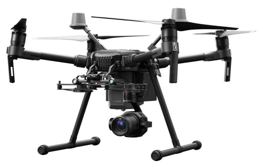
Alongside aerial photography comes cinematography. This is the use of a UAV to capture footage that will be used in a video, movie, or TV show, as an example. This is by no means the limit, as any video captured from a UAV can be used later for any purpose, however, many of these drones are special built for this purpose. The DJI Matrice, Yuneec Typhoon, or DJI Inspire are examples of consumer grade cinematography drones. Watch any behind the scenes featurette on any movie and you’re sure to see them using drones for shots that traditionally would have used helicopters.
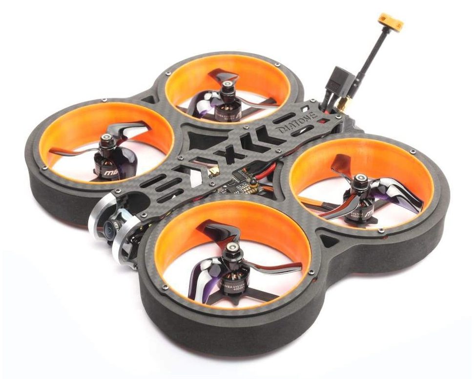
 Over the last year or so, Cinewhoops have made a mark on the hobbyist side of the equation, generally being in the 3” propeller size with ducts around the propellers. These make them safer to fly around people and cheaper to produce. If you’re looking to start down a cinematography path, maybe one of these is where you should get started!
 UAV Mapping
Using a drone for aerial mapping goes part and parcel with aerial photography. However, much of the activities under mapping involve some pretty extensive software, as well as special camera systems, depending on the type of mapping you want to accomplish. Furthermore, mapping using a UAV is MUCH more economical than using a helicopter for the same task, especially depending on how much and how often you want to conduct mapping operations.
Typically, for mapping applications, you want a UAV with a programmable flight path feature, and with the longevity to fly extended missions. Depending on the mapping mission, you can accomplish this with either a multirotor or a fixed wing application.
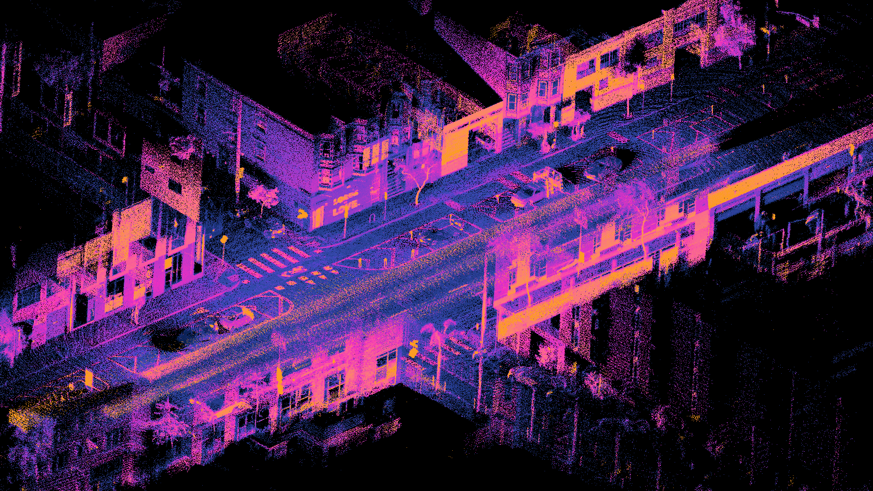
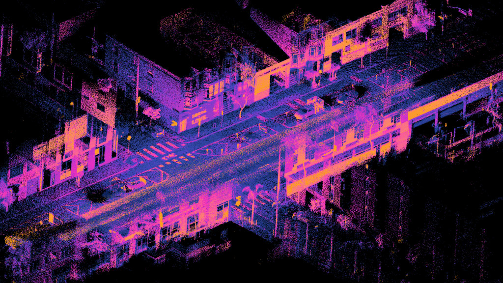
3D Mapping
There are a ton of reasons to use 3D mapping, from showcasing real estate, surveying, or even construction. This can use a variety of techniques, such as photogrammetry or LIDAR. Photogrammetry uses a multitude of photographs to take measurements and build a 3D model while LIDAR uses a laser pulses to hit a feature and measures the light reflected back to with a sensor. It uses thousands, or millions of these pulses to build a scene. Both systems have their best use cases, and one can be just as accurate as the other.
 Agriculture and Forestry
Mapping agriculture and forestry plots are a potential huge use case for UAV’s. Using camera’s capable of capturing NDVI imagery, or Normalized Difference Vegetation Index. NDVI imagery is a formula which equates to the following: NDVI = (Near Infrared – Red) / (Near Infrared + Red). Simply put, vegetation that is heathy and has plenty of chlorophyll tends to reflect more near infrared light (NIR) and green light. Unhealthy vegetation tends to absorb more of the NIR.
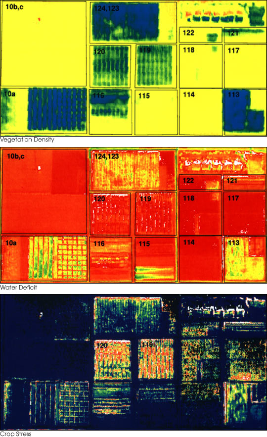 That’s great an all, but how does that help? Well by studying this data, a farmer can inspect his fields and can determine that a certain section may need more watering, while another maybe doing well, letting him conserve water. The same principal can be used in forestry, but with different objectives. Forestry service personnel can inspect the land and trees, and determine where there might be an upcoming fire hazard issue.
Search and Rescue
One of the most noble of UAV uses would be search and rescue. Deploying a UAV for this effort is massively more economical and offers the flexibility to get into smaller and tighter areas. Using both a standard camera as well as something like a FLIR (Forward Looking Infrared) makes the feasibility of this very high.
 In areas where a lot of people are going out hiking in the wilderness, this can be used by forestry and park ranger personnel to quickly identify where a person is, and how best to facilitate their recovery. This way, helicopters can deploy only when necessary. In the event of a disaster such as a tornado, hurricane, flooding, or earthquake, drones can quickly be deployed, while the infrastructure may not be immediately available for other search and rescue efforts.
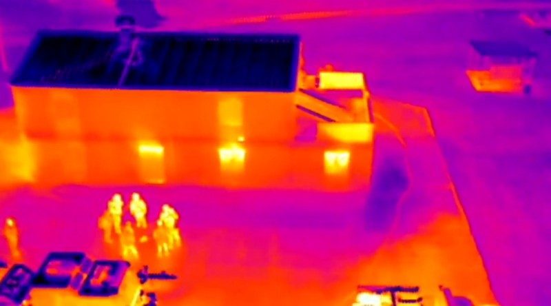
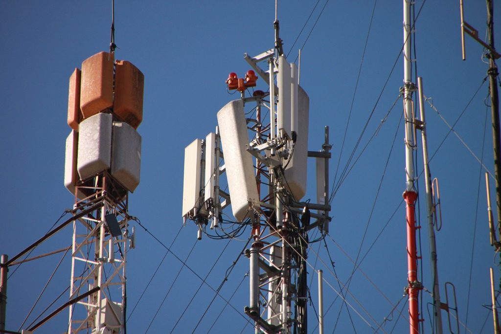
Inspection
More and more, companies are turning to UAV’s to inspect their infrastructure more efficiently and more effectively than ever before. Cell towers, power lines, railroads, bridges and buildings are all ripe for deploying this type of technology. It is infinitely safer and faster than sending a tech out to climb the structure unnecessarily only to find nothing is wrong. With the detail level of a high megapixel camera, that same tech can look at images (or perhaps a 3D map) to find issues, and then go out with all the right materials and tools to complete repairs.
 Conclusion
These are just a few different areas where UAV’s are starting to take to the field to help humanity do things that would either be more expensive, more labor intensive, or take longer. UAV’s provide a portable, often small form factor to accomplish many of these tasks otherwise relegated to dedicated personnel, or bigger and more expensive aircraft. Often times, UAV’s are modular, able to switch from one role to another, giving the operator the freedom to choose jobs.
While getting into one (or a few) of these industries might be hard and can be expensive at first, expect these areas to grow exponentially as time progresses. One key thing to do if you want to start exploring these different career areas, is to get your Part 107 certification if you are the United States. This will allow you to fly for the purposes of being compensated. You can find more information on getting your Part 107 certification here: Certified Remote Pilots and Commercial Operators
While FPV is a great hobby, some may want to turn their hobby into a career! These are just some of the options that you have that you can explore!